


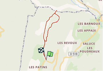
Belvédère de Revoulat

crocau
User

Length
5.8 km

Max alt
1171 m

Uphill gradient
185 m
Km-Effort
8.2 km

Min alt
1028 m

Downhill gradient
169 m
Boucle
Yes
Creation date :
2021-02-14 13:19:41.59
Updated on :
2021-02-15 15:37:29.481
1h49
Difficulty : Very easy

FREE GPS app for hiking
 SityTrail
IGN / Geographical institutes
SityTrail Plus
The world is yours!
About
Trail Walking of 5.8 km to be discovered at Auvergne-Rhône-Alpes, Drôme, La Chapelle-en-Vercors. This trail is proposed by crocau.
Photos


42 photos in total. Please click on a photo to see them all in the gallery.
Positioning
Country:
France
Region :
Auvergne-Rhône-Alpes
Department/Province :
Drôme
Municipality :
La Chapelle-en-Vercors
Location:
Unknown
Start:(Dec)
Start:(UTM)
688514 ; 4984011 (31T) N.
Comments